My problem was hubris. I had just hiked 500 miles from southern Arizona to the Utah border, in the process crossing the high desert of central Arizona and the Grand Canyon. I felt fit, acclimated to 100-degree temperatures — a hard-bitten hiker who could manage mile-high climbs, if not in a single bound, then certainly in a single day.
So I was not going to pay much attention to a little sign at the Angels Landing trailhead in Zion National Park that warned about a strenuous climb, a narrow route, cliff exposures, and the hazards of thunderstorms, darkness, ice and snow. National parks are full of warnings about backcountry hazards any experienced hiker considers as a matter of course. After all, I’d never climb out on an exposed ridge in a thunderstorm, and steep climbs and cliff exposures are par for the course on a mountain: Such warnings are for “tourists.”
In Your Bucket Because…
- The views are spectavular.
- This is one of those hikes that provides a real feeling of accomplishment
- Good for well-equipped hikers who are not afraid of heights.
And then I found myself sitting in the middle of the knife-edge ridge that leads to the final ascent, my legs shaking, paralyzed with fear, while casually dressed day-hikers hopped around me.
Acrophobia is an inconvenient dilemma for someone who loves trekking in high mountains as much as I do. My fear comes and goes, rarely striking with as much force as it did on the trail to Zion’s iconic Angels Landing, Like a person who controls seasickness by looking at the horizon, I can generally force my fear away by looking elsewhere or “talking myself down.” For me, acrophobia isn’t about actual danger, but perceived exposure.
Here there was both: The 1500 -foot sheer drop – and by sheer, I mean, like a skyscraper wall — was very real, and no matter where I looked, I was surrounded by empty space. According to Zion National Park’s website, since 2004, nine people have died from falls on the Angels Landing Trail.
Angels Landing Trail Basics

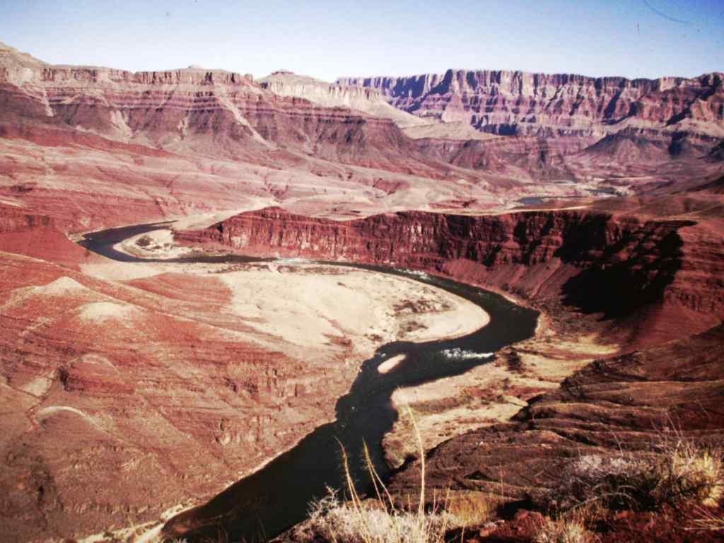
Located a few hours drive west of the “Four Corners” area of southern Utah, the cliffs and canyons of Zion National Park were cut and carved by wind and rain. Redrock and sandstone form a variegated landscape, and one of the best places to see the promontories and precipices is from the top of Angel’s Landing, described by an early 20th-century explorer as “so isolated only an angel could land on it.”
The 2.6-mile, 1500-foot climb to Angels Landing begins at the Grotto picnic area, accessible via shuttle buses on Zion Canyon Scenic Drive, which is closed to private vehicles in spring, summer, and early fall. Most of the hike to Angels Landing is contiguous with Zion’s six-mile West Rim Trail.
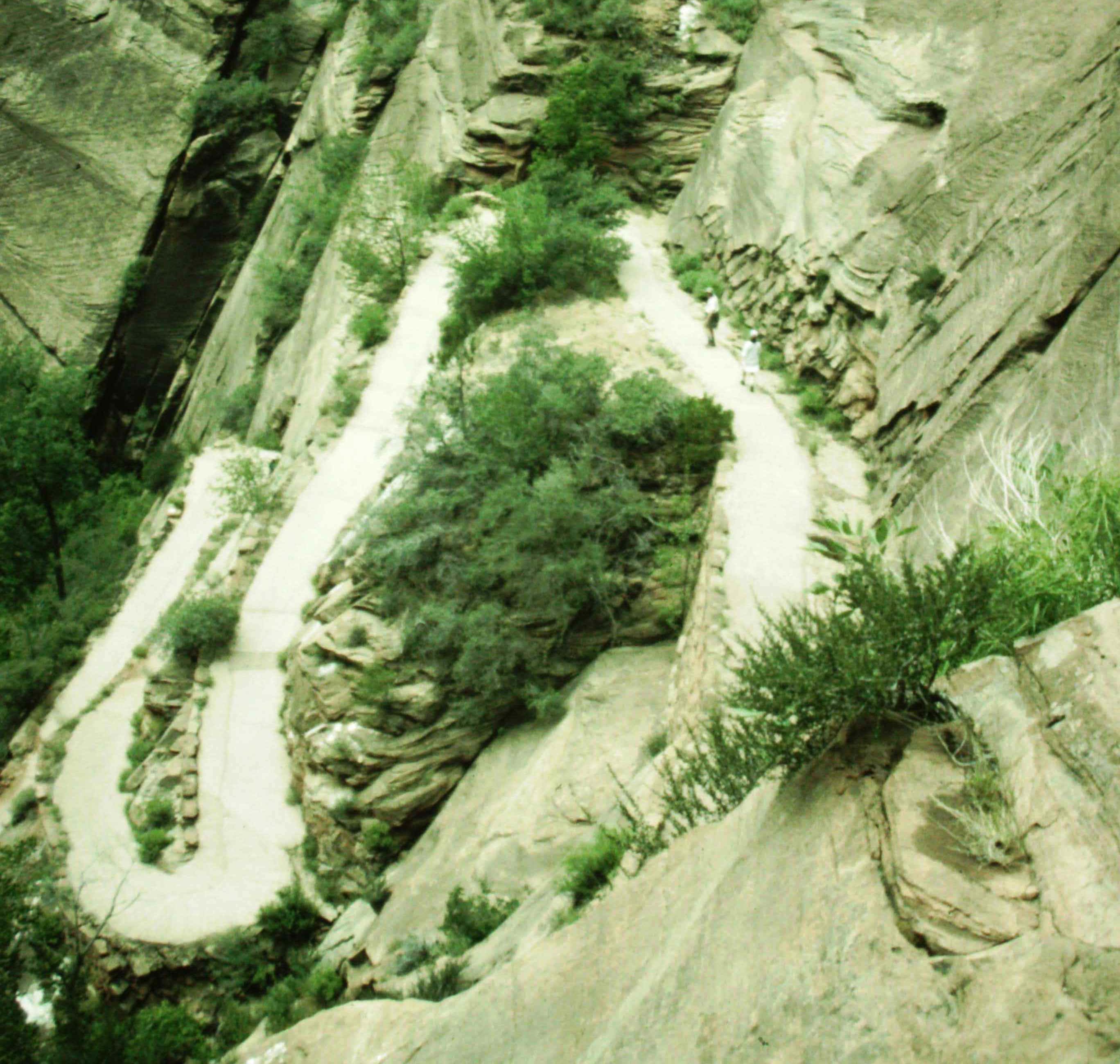
The first part of the ascent reinforced my confidence, as we crossed the Virgin River and strolled through shady cottonwood groves. The path was wide and rose gently, veering up and away from the river, growing steeper as it rose, ultimately following a series of switchbacks to Refrigerator Canyon (so named because of the welcome, almost palpable, shade cast by the cliffs on either side).
Exiting the Canyon, hikers begin climbing for real, ascending the 21 steep scrabbly switchbacks of Walter’s Wiggle, where a careless step can send dislodged rocks flying onto hikers directly below. The switchbacks end at Scouts Lookout, where the Angels Landing Trail leaves the West Rim Trail, and where my troubles began. From here, a short exposed scramble leads to the final ascent.
Tightrope in the Sky

The last section of the trail follows a knife edge (in geological terms, a sandstone fin) on either side of which the mountain drops away to reveal 1,500 feet of empty space. At one point, I found a place that was wide enough to allow me to sit down and catch my breath while others passed, casting pitying or encouraging glances my way. I sent my partner on ahead – I had no desire to have any witnesses to this struggle, and some kinds of encouragement don’t help. Then I sat for about 15 minutes until I thought I could try again. Cautiously, I got up and made my way, carefully keeping my eyes on the hikers right in front of me, thinking only of the next step.
The final ascent is a chain-assisted rock scramble, and once again, this section of trail proved that fear – my fear, at least – is completely irrational. Although the trail here is quite dangerous, with rock scrambling, uncertain footholds, crumbly sandstone, and that 1,500 foot drop to nowhere, with my face pressed against the rock, I had no problem at all. If I couldn’t see the danger, I could pretend it wasn’t there.
I reached the summit. Gray rock, blue sky, and me. In all-encompassing Southwestern silence, it was one of those triumph-on-the-mountain moments you see pictured in outdoor magazines, only there was no one to snap a picture. When I’d had enough, I turned back and almost flew back down the ridge that had so terrified me the first time, fueled by adrenaline and by my victory — not over the mountain (I know better than that), but over myself.
Practicalities
- If you’re afraid of heights, there’s good reason not to tackle the final half mile. But you can still get a great view from Scouts Lookout, without having to face the knife-edge and the final rock scrambles.
- Wear trekking shoes or boots with good traction and carry plenty of water.
- Stay off the ridge if there is ice or snow, high winds, heavy rain, or the possibility of thunderstorms.
- The area west of Four Corners also contains Arches, Bryce, and Canyonlands National Parks; Grand Canyon is nearby enough, to the south, to include in the same trip, and so are several national monuments and national forests, which offer excellent hikes without the crowds. Visit as many as you have time for.
Updated 2018

Nice evocative descriptions, and I’m going to Zion NP for the first time w/ the SATW Western Chapter in just a few weeks. I respectfully suggest, however, that you look at a map before relocating Zion to the Four Corners, where SE Utah, SW Colorado, NW Arizona and NE New Mexico meet. On an east-west continium (i.e., latitude), Zion NP is way closer to Nevada than to Colorado. Arches and Canyonlands near Moab are considerably north of the Four Corners, and Grand Canyon NP is halfway across Arizona from there.
Thanks for the comment… You’re right, and I’ve corrected the post. was thinking in terms of big (several hours-long) western road trip distances, and how people often DO visit all these parks and the Four Corners area in one trip, as we did. But it’s not the Four Corners, and I should have added its’s a several-hours drive to the west (which I have now done. I’m keeping the Four Corners reference there, though, because people know where it is, and because it often is included in the same trip — ie, I wanted to include it more from a travel planning perspective than a geography perspective. But the way I originally wrote it was incorrect, and thanks for pointing that out, because it could have mislead people.)